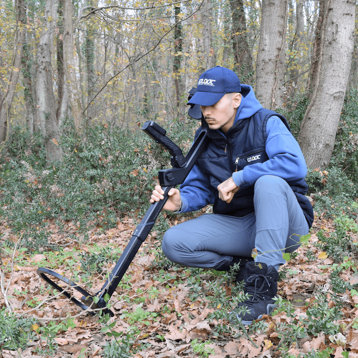
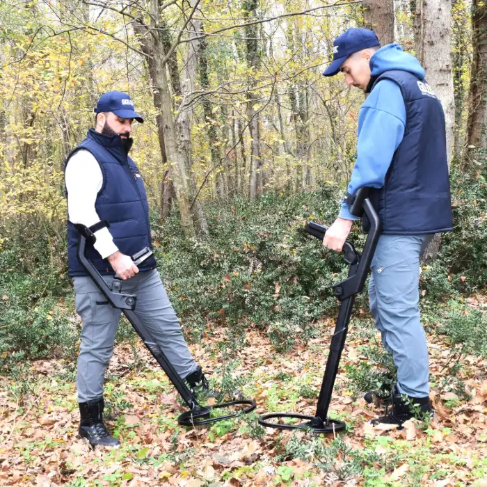
Professional 3D Ground Scanning &
Pulse Induction Technology
The world beneath our feet holds secrets that have remained hidden for centuries. From ancient
civilizations and buried treasures to modern geological anomalies and infrastructure, the need to
‘see’ into the earth has never been more critical. For professionals in archaeology, treasure
hunting, and industrial survey, the tools of the past are often insufficient for the complexities of
modern exploration. Enter the Goldot GR4 Dual, a device that represents the pinnacle of geophysical
detection and ground scanning technology. When Groundtech set out to design the GR4 Dual, the goal
was simple yet ambitious: to create a device that eliminates the need for multiple tools. Typically,
a seeker would need a 3D ground scanner for deep structure detection and a separate pulse induction
detector for pinpointing metallic objects. The GR4 Dual combines these two worlds seamlessly. It is
not just a metal detector; it is a comprehensive underground imaging system designed for those who
demand excellence and accuracy. In this deep dive, we explore how the GR4 Dual is redefining the
industry. We will look at its unique MFS-2 sensor technology, its incredible depth capabilities of
up to 15 meters, and the user-centric design that makes it a powerful ally in even the harshest
terrains.
Consider the challenges of an archaeological team working in a densely layered historical site.
Often,
artifacts from different eras are stacked on top of each other, making traditional surface-level
detection almost impossible. The evolution of ground scanning has moved from rudimentary magnetic
needles to sophisticated dual-sensor arrays. The GR4 Dual represents the latest iteration of this
evolution. By utilizing a dual-core processing architecture, the device can process electromagnetic
feedback at speeds previously reserved for laboratory equipment. This speed is vital when you are
out in the field, moving across uneven terrain. You need a device that can keep up with your
physical pace while maintaining the integrity of the data it collects. The GR4 Dual does exactly
that, ensuring that every square centimeter of the search grid is analyzed and recorded with
absolute
precision. This is why the device is favored not just by individual treasure hunters, but also by
academic institutions and forensic teams around the globe who require data that is both accurate and
verifiable.
Furthermore, the modern explorer faces an environment filled with electromagnetic noise. Power
lines,
cellular networks, and underground infrastructure can all create interference that would render a
standard detector useless. The GR4 Dual addresses this through its advanced filtering algorithms and
shielded sensor housing. It filters out the background ‘static’ of the modern world, allowing the
high-resolution MFS-2 sensors to focus solely on the magnetic anomalies originating from beneath the
soil. Whether you are mapping a forgotten Roman settlement or searching for buried industrial
components, the GR4 Dual provides a level of clarity that was once the exclusive domain of
multi-million dollar geophysics projects. It democratizes deep-earth imaging, putting
professional-grade power into a single, portable, and ergonomically designed unit.


The ‘Dual’ in GR4 Dual refers to its sophisticated integration of two primary detection systems: 3D
Ground Scanning and Pulse Induction (PI) Metal Detection. This combination is what sets the device
apart from its competitors. Most devices specialize in one area—either reaching great depths with
scanning or providing high sensitivity to small metals with PI. The GR4 Dual masters both. The 3D
scanning system utilizes the MFS-2 Dual Sensor (Gradiometer) technology. These sensors are
incredibly sensitive to magnetic field variations, allowing them to map out subterranean anomalies
with startling precision. This is achieved through a process called magnetometry, where the device
measures the intensity of the Earth’s magnetic field at multiple points and identifies the ‘noise’
or ‘interference’ caused by objects that shouldn’t be there. The MFS-2 sensor is a proprietary
development by Groundtech and represents a quantum leap in subterranean imaging. It operates by
detecting the subtle distortions in the natural magnetic flux of the Earth, which occur when it
encounters a non-natural subterranean object.
Unlike standard gradiometers used in entry-level devices, the MFS-2 is calibrated to filter out
environmental noise caused by electromagnetic interference (EMI) from power lines, cell towers, and
other modern electronics. This calibration is critical because, without it, the high sensitivity
required to reach 15 meters would lead to a chaotic and unreadable display on modern sites. On the
other hand, the Pulse Induction (PI) system provides a specialized mode for finding objects like
coins, rings, and smaller gold nuggets. This mode is particularly effective in mineralized soil
where traditional VLF detectors struggle with false signals. By switching to the PI mode, the GR4
Dual becomes a high-sensitivity metal detector that ignores ground mineralization, allowing you to
find targets that others miss. The PI system operates at a frequency pulse of 1 kHz, which is
optimized for deep penetration while maintaining sensitivity to medium-sized targets. In the
Platinum
Edition, these sensors have undergone a secondary stage of high-precision calibration, ensuring that
even the most subtle magnetic anomalies are captured.
The synergy between these two technologies—Ground Scanning and Pulse Induction—means that the seeker
no longer has to choose between depth and detail. You can use the 3D scanning mode to identify a
large anomaly at a depth of 12 meters, and then use the Pulse Induction system to verify if there
are associated smaller metallic objects closer to the surface. This multi-layered approach to
discovery is what makes the GR4 Dual an indispensable tool for serious treasure hunters. It provides
a complete subterranean overview, from the broad geological context down to the specific metallic
signature of a single artifact. By integrating these systems into a single core unit, Groundtech has
eliminated the mechanical fatigue of carrying multiple devices, allowing explorers to cover more
ground and maintain higher levels of concentration during long field expeditions.
| Detection System | 3D Ground Scan + Pulse Induction |
| Scanning Depth | Up to 15 Meters (49.2 ft) |
| Core CPU | 240 MHz Dual Core Platinum Processor |
| Connectivity | Bluetooth 5.0 (Optimized for G-Portal) |
| Manufacturer Warranty | 2 Years Official Full Coverage |
While most consumer-grade detectors are limited to a few feet, the GR4 Dual operates on a different
scale entirely. In its 3D Ground Scan mode, the device can reach depths of up to 15 meters. This is
made possible by the way the MFS-2 sensors interact with the Earth’s magnetic field. Unlike active
scanning which emits a signal and waits for a reflection, the GR4 Dual’s passive sensors detect
variations in the existing magnetic field caused by underground objects or voids. This passive
method is far more reliable for deep structure mapping, as it doesn’t suffer from the signal
attenuation often found in active radio-wave systems. For example, in highly conductive or wet clay
soils, Ground Penetrating Radar (GPR) often loses its signal after only a few meters. The GR4 Dual,
however, remains effective because the Earth’s magnetic flux is not impeded by soil moisture in the
same way that radio frequencies are. This makes the GR4 Dual the superior choice for archeological
surveys in humid climates or areas with high ground water tables.
Moreover, the Live Scan mode is a game-changer for large-area surveys. Instead of spending hours
preparing a full grid, you can perform a quick walk-through. As you walk, a real-time graph and
color-map are generated. If you hit a large metallic object or a void, the screen will spike
immediately. This allows you to ‘pinpoint’ a general area of interest before committing to the
resource-intensive process of high-resolution grid scanning. The real-time nature of this feedback
allows teams to iterate on their search strategy while they are still on the site. If a Live Scan
reveals a potential linear structure, the team can immediate adjust their grid to capture the full
layout of the buried wall or tunnel. This level of dynamic field analysis significantly increases
the discovery rate and ensures that no potential target is overlooked due to rigid search protocols.
Data interpretation is where the real work begins. Collecting data in a grid is only 50% of the
process; the other 50% is how you interpret those signals. The G-Portal application, running on our
high-speed Dual Core platform, provides an interactive environment. You can rotate the 3D map to
look for structural alignments—for example, the straight lines of a buried wall or the round corners
of an ancient tomb. The filtering system allows you to peel back layers of the ground virtually. If
the surface is cluttered with modern magnetic bits, you can adjust the filter sets to focus deeper,
where the magnetic field is undisturbed. This level of geological ‘slicing’ was previously only
available in massive industrial equipment, but now it fits into your pocket. By visualizing the data
in three dimensions, seekers can understand not just the location, but the context of their
find—determining if a metallic object is inside a stone chamber or simply buried alone in the dirt.


One of the defining features of a professional-grade detector is its ability to maintain signal
integrity in diverse and challenging environments. The GR4 Dual’s Platinum Edition shines in this
regard. Whether you are scanning the high-mineralization volcanic soils of Iceland, the salt-heavy
coastal regions of the Mediterranean, or the iron-rich clays of the African Savannah, the device’s
internal algorithms work to filter out ground noise. This process ensures that the data you see is a
true representation of underground anomalies. Furthermore, the device is designed to operate in
extreme temperature ranges, from -10°C to +50°C. This wide operational window is essential for
global exploration. During a typical search, the device’s internal sensors monitor hardware to
prevent thermal drift, ensuring that your 3D scans remains consistent from the first step of the
grid to the last. This thermal stability is achieved through a specialized housing that dissipates
heat while protecting the internal oscillator from external temperature fluctuations, preserving the
exact timing required for high-accuracy MFS-2 signal sampling.
Additionally, the Platinum Edition features enhanced shielding against local radio frequency
interference (RFI), meaning that you can operate near cell towers or industrial sites without losing
the clarity of your scan. This commitment to signal purity is what makes the GR4 Dual a world leader
in underground detection technology. The device also supports automatic ground balancing, which
recalibrates the system every few seconds to account for shifting soil composition within the same
search grid. This is particularly useful in ancient urban sites where the soil can change from
loosely packed dirt to dense building rubble within a few meters. By maintaining a constant ‘null’
background state, the GR4 Dual ensures that even the faintest signals from deeply buried artifacts
are not lost in the background noise of the soil itself. This level of environmental awareness
transforms the device from a simple metal finder into a sophisticated geological tool capable of
mapping the most complex subterranean environments with ease.
The GR4 Dual features a sleek, ergonomic design that is lightweight enough for long hours of
exploration. The highlight of the new model is the integrated color screen. Unlike earlier versions
that required a tablet or phone to view any data, the GR4 Dual allows you to perform basic analysis
and see scan results directly on the device. This independence is crucial for working in remote
areas where managing multiple devices is difficult. To maximize your success, proper field technique
is essential. Maintain a robotic, steady pace and walk in straight lines; even small deviations can
cause distortions in the 3D model. Always perform a ground balance calibration before starting a
deep scan. Remember to carry a high-capacity power bank for your mobile devices to ensure the
Bluetooth link remains active for high-resolution 3D visualization on larger tablet screens when
required for detailed archaeological documentation.
High-resolution grid mapping up to 15m…
Walk and see! Real-time color feedback…
Non-motion acoustic mode for centering…
Dedicated pulse induction mode for coins…
Choosing the right equipment is the most important decision a seeker can make. Known for
uncompromising quality, Goldot ensures that every unit sold is a genuine, high-performance tool.
Every GR4 Dual comes with a 2-year official warranty, giving you peace of mind. We provide training
materials, manuals, and video guides, ensuring that users can master the technology quickly. Our
network of support is worldwide, understanding the challenges of geophysical discovery. At Goldot,
we believe every discovery tells a story. The GR4 Dual was built to help you uncover those stories
with scientific accuracy. Join the global community of professional explorers who trust the GR4 Dual
for their most critical missions. The secrets of history are waiting just below the surface—are you
ready to find them? Success in the field comes from the combination of local knowledge and high-tech
verification. The journey of 1000 years starts with a single scan. By investing in a Goldot device,
you aren’t just buying hardware; you are gaining a partner in your quest for discovery. Our legacy
is built on the success of our users, and we take pride in every tomb revealed and every artifact
saved from the depths of time.
The Platinum Edition of the GR4 Dual is designed for those who refuse to settle for second best.
Every component is built to survive the rigors of global exploration. It bridges the gap between
traditional archaeology and cutting-edge geophysics, making professional exploration accessible to
anyone with the vision to seek what is hidden. With the Platinum Edition, you are not just buying a
detector; you are acquiring a sophisticated geological analytical tool that will pay for itself in
the clarity of the discoveries you make. The secrets of history are waiting just below the
surface—are you ready to find them? Whether you are trekking through the humid humidity of South
America, the arid deserts of the Middle East, or the frozen landscapes of Northern Europe, the GR4
Dual remains your most reliable companion. The philosophy behind this device is simple: absolute
precision in absolute depth. Every buried foundation, every forgotten treasure cache, and every
ancient burial chamber is within reach when you have 15 meters of visual penetration at your
disposal. This is your eye into the unknown, a bridge to civilizations long past.
Finally, let us reflect on the legacy of discovery. Every civilization since the dawn of time has
left a mark upon the earth. Some are obvious, while others are hidden beneath layers of history and
soil. The GR4 Dual is your key to unlocking these chapters. Join the global elite who refuse to
compromise on their equipment and start your journey of discovery today. The commitment to
excellence that defines Groundtech is mirrored in the success of our explorers. By pushing the
boundaries of what is possible in subterranean imaging, we provide the tools that turn legends into
verified history. Are you ready to see what others miss? The next great discovery is waiting for
you, and it is closer than you think. Take the first step into the subterranean world with the
confidence that only the GR4 Dual Platinum Edition can provide. Your journey into the unknown begins
now.

Join the ranks of professional explorers today.