Tero Vido 3D System Pro Ground Scanner


Please login to leave a review:
Loading reviews...
Store & Products
Warranty & Training
Shipping & Payment



- USD: 2.800$
- USD: 2.100$
- USD: 650$
- USD: 4.500$
- USD: 15.900$
Coupon Opportunity!
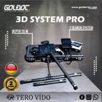
The Tero Vido 3D System Pro Ground Scanner combines three probes with tablet-based 3D software for subsurface surveys. Tero Vido advertises up to 25 metres under suitable conditions; ground scanning depth and anomaly interpretation depend on site conditions and require independent confirmation.
Tero Vido 3D System Pro Ground Scanner
The Tero Vido 3D System Pro Ground Scanner records measurements for subsurface imaging with interchangeable probes. This ground scanning system is intended to help assess metal and void anomalies before closer investigation.
The Tero Vido 3D System Pro Ground Scanner displays survey data on a tablet for review in Tero Vido 3D software. Ground scanning images require careful interpretation and independent confirmation before excavation.
Ground Scanner 3D Imaging
The Tero Vido 3D System Pro Ground Scanner is intended for professional surveys of varied terrain. Its three probes support different measurement layouts, while ground scanning results depend on the target, soil and operator method.
The Tero Vido 3D System Pro Ground Scanner package lists one 85 cm vertical probe and two horizontal probes of 50 and 100 cm. The manufacturer advertises up to 25 metres depth under suitable conditions; ground scanning at a particular site cannot be guaranteed to that depth.
Ground Scanner Target Analysis
- 1. Mineral Filtering
Thanks to its unique mineral filtering feature, you can easily remove false signals caused by mineralized soil, focusing only on real targets. - 2. Detailed Void Detection
Designed to detect underground spaces such as **rooms, tunnels, tombs, and shelters**. It calculates width, length, depth, and dimensions instantly. - 3. Real-Time Visualization
As you scan the ground with the probes, results are displayed in real-time on the included tablet screen. Data can be stored indefinitely for later analysis. - 4. Versatile Probe System
Includes 3 specialized probes:• Vertical Probe (85 cm): For high-detail deep scanning.• Horizontal Probe (50 cm): For standard area scanning.• Horizontal Probe (100 cm): For rapid scanning of very large areas.
Ground Scanner Package Contents
- ✔ Vertical Probe (85 cm)
- ✔ Horizontal Probe (50 cm)
- ✔ Horizontal Probe (100 cm)
- ✔ Infrared Soil Temperature Meter
- ✔ Tablet with Tero Vido 3D Software
- ✔ Charger & Travel Adapter
- ✔ Wireless Headphones (Bluetooth/WiFi)
- ✔ Telescopic Carrying Handle
- ✔ Tablet Protection Bag
- ✔ Impact Resistant Pelicase Bag
Ground Scanner Technical Specifications
Ground Scanner Detailed Specifications
| 1. Application Areas | Archaeology, Mining, Treasure, Voids, Cables |
|---|---|
| 2. Max Depth | 25 Meters |
| 3. Operating Modes | 3D Ground Scan, Pinpoint, Live View, Detector Mode |
| 4. Target Discrimination | Magnetic (Iron) vs. Precious (Gold/Silver) |
| 5. Probe Technology | Ultra-sensitive sensors (Univ. Leipzig) |
| 6. Certificates | CE, FCC, WEEE (DE 73865556), ICC Origin |
| 7. Data Storage | Unlimited (Stored on Tablet) |
| 8. 3D Analysis | Tero Vido 3D Software (Included) |
| 9. Measurements | Width, Length, Depth, Dimensions |
| 10. Warranty | 2 Years Manufacturer Warranty |
Share this Device
Ground Scanner Buyer Questions
Q: What maximum depth is advertised for the Tero Vido 3D System Pro Ground Scanner during ground scanning?
A: Tero Vido lists up to 25 metres for the Tero Vido 3D System Pro Ground Scanner. Actual ground scanning depth varies with target size, terrain and technique, so confirm a suspected anomaly independently.
Q: Which probes come with the Tero Vido 3D System Pro Ground Scanner for ground scanning?
A: The manufacturer’s package lists an 85 cm vertical probe and 50 cm and 100 cm horizontal probes for the Tero Vido 3D System Pro Ground Scanner. Check the offered configuration before purchase because ground scanning accessories may vary by package.
Q: Can the Tero Vido 3D System Pro Ground Scanner show voids and tunnels through ground scanning?
A: Tero Vido describes the Tero Vido 3D System Pro Ground Scanner as a survey device for subsurface spaces and metal anomalies. A ground scanning image is an interpretation aid; it cannot alone prove that a cavity or tunnel exists.

Technical Specifications
| SKU | N/A |
|---|