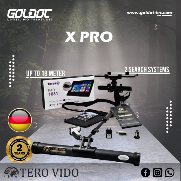
Tero Vido X Pro 3D Ground Scanner


Please login to leave a review:
Loading reviews...
Store & Products
Warranty & Training
Shipping & Payment



- EUR: € 2.515,24
- EUR: € 1.886,43
- EUR: € 583,89
- EUR: € 4.042,35
- EUR: € 11.857,56
Coupon Opportunity!
The Tero Vido X Pro 3D Ground Scanner uses a 100 cm probe and tablet-based software to display subsurface survey measurements. Tero Vido lists up to 21 metres depth for suitable targets; ground scanning results vary with target and terrain and require independent confirmation.
Tero Vido X Pro 3D Ground Scanner
The Tero Vido X Pro 3D Ground Scanner records subsurface measurements for review as a three-dimensional model. Its ground scanning results can help plan closer investigation of metal or void anomalies.
The Tero Vido X Pro 3D Ground Scanner is intended for professional site surveys with a tablet-based display. A ground scanning image requires interpretation and independent checks before excavation.
3D Ground Scanner Technology
The Tero Vido X Pro 3D Ground Scanner uses a 100 cm probe that can be operated vertically or horizontally, according to its manufacturer. This ground scanning arrangement supports different survey spaces and transfers measurements for software analysis.
The Tero Vido X Pro 3D Ground Scanner is marketed with a maximum depth of 21 metres for suitable large targets. Ground scanning depth depends on target size, soil and measurement method, so that figure is not a guaranteed result for every site.


3D Ground Scanner Comparison
| Feature | Tero Vido Basic | Tero Vido X Pro 3D Ground Scanner |
|---|---|---|
| Probes Included | Vertical Sensor Only | Vertical + 50cm & 100cm Horizontal |
| Windows Tablet | Optional / Not Included | Included (Pre-configured) |
| Software Version | Standard 3D Software | Universal 3D Software PRO |
| Infrared Sensor | No | Yes (Integrated for Temp Check) |
| Max Coverage | Standard Ground Area | Massive Area (100cm Probe) |
3D Ground Scanner Operating Modes
- 1. 3D Ground Scanning
Maps the sub-soil in ultra-high resolution. Visualizes anomalies in 3D, allowing precise depth, shape, and size measurement. - 2. Pinpointer
Allows you to narrow down the target location to exact coordinates before digging. - 3. Live Scan
Real-time visualization function. See hidden objects on the screen as you walk over the ground without stopping. - 4. Magnetometer (Acoustic/Visual)
Detects ferromagnetic metals near the surface with rapid audio and visual signals, perfect for quick clearing. - 5. Object Discrimination
Software-assisted color coding (Red for magnetic metals, Yellow/Green for precious metals, Blue for voids/cavities).
3D Ground Scanner Package Contents
- ✔ Tero Vido X Pro Main Unit
- ✔ 85cm Vertical Sensor Probe
- ✔ 50cm Horizontal Sensor Probe
- ✔ 100cm Horizontal Sensor Probe
- ✔ Pre-configured Windows Tablet
- ✔ Universal 3D Software (USB Flash)
- ✔ Infrared Thermometer
- ✔ Fast Charger & Power Adapters
- ✔ Heavy Duty Pelican Transport Case
- ✔ User Manual & Warranty Certificate
3D Ground Scanner Software
The Tero Vido X Pro 3D Ground Scanner listing includes a tablet with Tero Vido 3D software for visualization and review. Save the ground scanning dataset and compare repeated passes before interpreting a subsurface anomaly.
 Windows Native Software
3D Ground Scanner Specifications
3D Ground Scanner Detailed Specifications
| 1. Application | 3D Ground Scanning, Archaeology, Utilities |
|---|---|
| 2. Sensor Technology | Multi-axis magnetic field sensors |
| 3. Measurement Rate | Up to 100,000 measurements per second |
| 4. Max Depth Range | Up to 21 Meters (Target dependent) |
| 5. Microprocessor | High-speed cortex processor |
| 6. Display Unit | Windows Tablet (Included) |
| 7. Wireless Connection | Bluetooth 4.0 |
| 8. Battery | High-capacity Li-ion (Built-in) |
| 9. Operating Time | Up to 15 Hours continuous use |
| 10. Charging Time | 1.5 Hours (Fast Charge) |
| 11. Software Interface | Tero Vido Universal 3D Software PRO |
| 12. Protection Class | IP54 (Dust & Splash Proof) |
| 13. Operating Temp | -10°C to 50°C |
| 14. Transport Case | Heavy-duty hard shell case |
| 15. Warranty | 2 Years |
Tero Vido X Pro 3D Ground Scanner Video Demonstration
Share this Device
3D Ground Scanner Frequently Asked Questions
Q: What depth does Tero Vido state for the Tero Vido X Pro 3D Ground Scanner in ground scanning?
A: The manufacturer lists up to 21 metres for the Tero Vido X Pro 3D Ground Scanner. Actual ground scanning depth varies with target properties and terrain; confirm any interpreted anomaly with another suitable method.
Q: Does the Tero Vido X Pro 3D Ground Scanner package include a tablet for ground scanning?
A: The manufacturer’s listing for the Tero Vido X Pro 3D Ground Scanner includes a special tablet with its 3D software installed. Check the seller’s current package and software version before ordering the ground scanning system.
Q: Can the Tero Vido X Pro 3D Ground Scanner be used in mineralized soil for ground scanning?
A: Tero Vido describes the Tero Vido X Pro 3D Ground Scanner as suitable for varied ground, including mineralized sites. Ground scanning quality still depends on careful survey technique and interpretation; a scan does not prove a target’s identity.

Technical Specifications
| SKU | tero-vido-x-professional |
|---|