

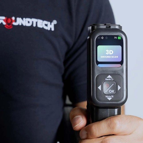
A reliable Groundtech GR4 Dual setup guide should begin before the first scan. The GR-4 Dual is not a conventional metal detector where the operator simply switches it on and follows an audio signal. It combines an MFS-2 Dual Sensor 3D ground-scanning system with an integrated 1 kHz Pulse Induction detector, a built-in color screen and optional G-Portal analysis for Android and iOS. Groundtech currently lists 3D Ground Scanning, Live Scanning, Pinpointer, Detector Quick Scan, Detector Advanced Scan and 3D Ground Scanning Detector functions for the GR-4 Dual.
This makes preparation important. Survey boundaries, scan direction, sensor consistency, PI coil use, data review and correct interpretation all influence the value of the information you collect.
The original setup brief appropriately focuses on assembly, software connection, sensor alignment, scan-grid planning and consistent data collection. One important correction is necessary, however: the current GR-4 Dual does not require a phone or tablet for basic operation. Groundtech and Goldot-Tec confirm that the new generation model has an integrated display and can operate independently. G-Portal is available when you want more detailed 3D/4D analysis, saved data and reporting.
The goal of setup is therefore not to force the scanner to show a target. It is to collect repeatable information that helps you decide whether an anomaly deserves further professional investigation.

Plan the Survey Before Unpacking the GR4 Dual
The quality of a 3D scan depends partly on how consistently the search area is covered.
Before assembling the scanner, define the objective of the survey.
Are you investigating a suspected buried metal mass? Looking for a possible cavity or tunnel? Reviewing an archaeological area? Checking a site where a previous detector produced an anomaly?
The answer determines which GR-4 Dual function is most useful.
Remove Unnecessary Variables from the Survey Zone
Walk through the site before scanning.
Identify obvious surface metal such as:
- Vehicles
- Fencing
- Metal stakes
- Shovels and digging equipment
- Reinforced structures
- Large pipes
- Electrical installations
- Other operating detectors
Where possible, keep movable metallic equipment away from the scan area.
Also understand the site’s history before interpreting a scan. Known utilities, previous excavation, fill material or buried construction debris can all create anomalies that should not automatically be interpreted as treasure or a cavity.
Where underground utilities may exist, obtain appropriate site information and permissions before considering excavation.
Decide Whether You Need 3D or PI Detection First
GR-4 Dual combines two important technologies.
Its MFS-2 Dual Sensor system is used for 3D ground scanning and anomaly analysis.
Its integrated 1 kHz Pulse Induction system adds conventional metal-detection functionality for challenging mineralized and saline conditions. Groundtech distinguishes the Dual model from the standard GR-4 specifically by the inclusion of the PI detector.
This gives you more than one possible workflow.
You may begin with a broad 3D survey and then use another mode to investigate a suspicious area more closely.
Or you may use a detector mode to confirm whether an area produces a repeatable metal response.
That versatility is one reason to view the GR4 Dual system and package configuration before purchasing rather than assuming that the standard GR-4 and GR-4 Dual are interchangeable.
Assemble and Inspect the Scanning Components
Groundtech currently lists the GR-4 Dual package with the main unit, MFS-2 Dual Sensor, PiD35 detector search coil, charging adapter, carrying equipment and user documentation. Goldot-Tec’s current listing also identifies the main unit, detachable sensor module, PI search coil, Type-C charging equipment and transport case.
Because seller packages can change, confirm the exact bundle before checkout.
Inspect Every Component Before Power-On
Lay out the equipment in a clean location.
Check:
- Sensor housing
- Main unit
- Search coil
- Connectors
- Charging interface
- Body joints and adjustment points
- Carrying equipment
- Visible cables where applicable
Do not continue with a component that appears cracked, bent or damaged.
The goal of the first setup is to create a known-good starting point. If you begin with a questionable sensor connection and later see inconsistent data, it becomes difficult to know whether the problem came from technique, terrain or hardware.
Confirm Battery Readiness
Groundtech specifies a rechargeable 3.7 V Li-ion battery and Type-C 25 W charging for the GR-4 Dual. Published operating time is approximately ten hours in the 3D scanning system and approximately six hours when using the Pulse Induction detector system.
Those figures are manufacturer specifications, not guarantees for every battery age or operating condition.
Charge the system before a planned survey instead of depending on the remaining battery from a previous session.
A scan should ideally be completed under stable conditions rather than interrupted midway because the operator started with insufficient power.
Use the Integrated Display Before Adding Extra Devices
The current GR-4 Dual has a major usability advantage over older phone-dependent scanning workflows: the integrated color display allows standalone operation.
Goldot-Tec states that scans and results can be evaluated directly on the unit without needing a phone or tablet. Groundtech likewise confirms that settings and results appear on the integrated display.
Treat G-Portal as an Advanced Analysis Tool
G-Portal is still valuable.
Groundtech provides the application for Android and iOS, and Goldot-Tec describes it as a tool for more detailed 3D/4D analysis and reporting. The device supports Bluetooth 4.2 BLE for wireless communication.
A practical workflow is:
Use the integrated screen for setup and immediate field evaluation.
Save important scan data.
Transfer or review selected results in G-Portal when deeper visual inspection is useful.
Compare repeated scans rather than judging one screenshot alone.
This approach prevents the phone from becoming an unnecessary dependency while preserving the advantages of advanced software analysis.
Establish a Clean Starting Baseline
Before interpreting underground colors or shapes, confirm that the scanner is behaving consistently in the environment.
A 3D ground scanner measures anomalies. It does not provide direct visual photographs of buried objects.
Groundtech’s MFS-2 Dual Sensor is a gradiometer system rated at ±2000 µT. Its role is to collect subsurface variation that can then be processed and displayed graphically.
Keep the Survey Procedure Consistent
For the first passes, avoid experimenting with several unrelated settings simultaneously.
Select the appropriate scanning function and establish a repeatable technique.
As a conservative field practice:
- Begin on relatively clear ground.
- Keep external metallic objects away where possible.
- Maintain a consistent sensor orientation.
- Avoid sudden twisting.
- Keep body movement controlled.
- Complete each pass before changing settings.
These are good survey practices rather than a manufacturer promise that every anomaly will represent a confirmed object.
The GR-4 Dual is designed to detect differences associated with buried metals, magnetic objects and void-type structures, but Groundtech also makes clear that obtainable depth varies with soil structure, object size and scanning function.
Mark a Consistent Survey Grid
For a saved 3D survey, repeatability is more useful than wandering freely across the site.
Live Scan is designed for faster real-time scouting without the same requirement for a structured stored survey. A deliberate 3D scan benefits from a repeatable route.
Use Straight Parallel Lines Where the Terrain Allows
Define the corners of the survey area.
Choose one direction.
Walk parallel passes while keeping spacing and movement as consistent as practical.
Do not abruptly shorten some passes or dramatically change speed in the middle of the survey.
The purpose of the grid is not to create an artificial target pattern. It is to ensure that position changes in the resulting dataset correspond as closely as possible to real movement across the ground.
Keep Sensor Height and Walking Technique Consistent
Suddenly lifting, tilting or rotating a gradiometer sensor can affect collected information.
Try to maintain:
- Similar sensor height
- Similar orientation
- Similar walking speed
- Straight travel direction
- Smooth turns outside the active scan line
Uneven terrain may make perfect consistency impossible. In that case, prioritize controlled technique and document unusual terrain conditions so they can be considered during analysis.
For buyers comparing this scanning workflow with other Groundtech systems, you can explore Groundtech scanners supplied by Goldot-Tec and determine whether GR-4 Dual’s combination of 3D scanning and PI detection is necessary for your projects.
Understand the GR4 Dual Scanning Modes Before Collecting Data
Groundtech currently describes six scanning functions for the new-generation platform.
Knowing what each is designed for helps prevent misuse.
3D Ground Scanning
This mode is intended to collect information that can be represented in 3D.
Use it when the goal is a structured subsurface survey rather than simply identifying an immediate nearby response.
Groundtech states that the system can analyze buried metals, magnetic objects and void structures and that G-Portal can provide more detailed 3D/4D analysis.
Live Scanning
Live Scan is intended for fast graphical feedback while moving over the ground.
It can be useful when scouting a larger area before committing time to a detailed 3D grid.
Pinpointer
Pinpointer functionality is intended to help narrow the location of an anomaly after it has already been identified.
It should be treated as a localization stage rather than the initial wide-area survey.
Detector Quick Scan
The GR-4 Dual’s integrated Pulse Induction system allows quicker conventional metal-search operation.
Goldot-Tec describes Quick Scanning as a PI mode for detecting ferrous and non-ferrous metals.
Detector Advanced Scan
Advanced PI scanning provides greater setting control and is intended for more demanding detection conditions.
This is where experience with ground response becomes more valuable.
3D Ground Scanning Detector Mode
Groundtech additionally lists a combined 3D Ground Scanning Detector function that uses detector information together with G-Portal analysis.
This combination is a key reason the GR-4 Dual belongs in a different category from a basic imaging-only scanner.
Run Controlled Passes Without Distorting the Dataset
A scanner can only process the measurements supplied to it.
Walking inconsistently does not improve the analysis simply because the software displays a polished 3D graphic.
Avoid Sudden Direction Changes Inside a Scan Line
Keep movement smooth.
Complete a line before moving to the next.
If you lose your orientation, restarting the survey may be more reliable than continuing with a badly distorted path and later trying to interpret it.
Repeat Suspicious Areas from Another Direction
A strong anomaly deserves verification.
When a suspicious result appears, scan the area again rather than immediately choosing an excavation point.
A useful field-validation approach is to:
Repeat the survey.
Approach from another direction.
Check whether the anomaly remains in approximately the same physical location.
Use another appropriate GR-4 Dual mode when useful.
Compare the resulting datasets.
A feature that changes dramatically whenever scan direction changes deserves more caution than an anomaly that remains spatially repeatable.
This method does not prove what the object is, but it can improve confidence that the observation is not simply the result of one inconsistent pass.
Separate 3D Imaging from Pulse Induction, VLF and GPR
The GR-4 Dual is a multi-system detector, but those technologies must not be described as interchangeable.
Understand the MFS-2 3D Sensor
The MFS-2 Dual Sensor is a gradiometer-based imaging technology.
It collects variations used for graphical analysis of underground anomalies.
This is the core of the GR-4 Dual’s 3D scanning function.
Understand the Integrated PI Detector
The additional 1 kHz Pulse Induction detector is designed for metallic target detection and challenging soils.
Groundtech specifically distinguishes GR-4 Dual from the standard GR-4 because the standard model does not include the PI detector.
VLF Is a Different Metal-Detection Technology
A VLF detector generally uses continuous electromagnetic transmission and can provide detailed discrimination or target identification depending on the machine.
It is not the same as the GR-4 Dual’s PI or gradiometer functions.
GPR Is Not the Same as GR4 Dual 3D Scanning
Ground Penetrating Radar transmits radar energy into the ground and interprets reflected signals.
The GR-4 Dual specifications identify MFS-2 gradiometer technology and Pulse Induction—not a GPR radar transmitter.
Do not purchase it assuming that every product marketed as “3D” is automatically GPR.
Long-Range Systems Are Another Category
Long-range locator systems are designed around broad directional searching and should not be confused with structured ground imaging.
Understanding these categories prevents a buyer from selecting sophisticated equipment that still does not match the actual survey objective.
If your project requires a broader comparison of subsurface technologies, you can compare professional underground imaging detectors through Goldot-Tec before committing to the GR-4 Dual.
Review Scan Data Before Choosing an Excavation Area
Colored graphics should guide investigation, not replace judgment.
Groundtech states that G-Portal can graphically represent magnetic and non-magnetic anomalies and provide detailed 3D/4D analysis.
That does not mean a particular color automatically proves that a specific buried object is gold, a tomb or a tunnel.
Separate Software Color from Confirmed Target Identity
Treat a visual anomaly as evidence that requires interpretation.
Consider:
- Shape consistency
- Approximate dimensions
- Repeatability
- Position within the survey
- Local geology
- Known site history
- Responses from other GR-4 Dual modes
- Possible modern infrastructure
The most responsible decision is based on several observations rather than a single color patch.
Save Files with Clear Survey Notes
Where G-Portal is used, organize saved surveys logically.
Record the area, date, scan direction, terrain and any notable circumstances.
Good records allow you to revisit a site and compare results rather than relying on memory.
Groundtech’s Bluetooth 4.2 BLE connection and G-Portal mobile application are designed to support this extended analysis workflow.

Understand the Published Depth Figures Correctly
Groundtech currently lists the GR-4 Dual 3D system at up to 15 meters and the integrated detector system at up to 3 meters. Both Groundtech and Goldot-Tec make clear that results are dependent on soil and target conditions.
These figures should never be presented as guaranteed depths.
Target size, target composition, orientation, soil structure, mineralization, scan technique, detector mode and environmental conditions all influence practical performance.
A large underground structure is fundamentally different from a small coin.
This is another reason setup and interpretation matter more than simply quoting the maximum specification.
Purchase the Correct GR4 Dual Package and Training
GR-4 Dual is sophisticated enough that the buying decision should include training and package verification, not just the device itself.
Groundtech’s official package description identifies the main unit, MFS-2 Dual Sensor, PiD35 detector search coil, charging adapter, carrying equipment and user manual.
Goldot-Tec currently lists a main unit, detachable sensor module, PI search coil, Type-C 25 W charger, hard transport case and warranty documentation.
Because those descriptions differ slightly in carrying-equipment terminology, confirm the exact current contents before checkout rather than assuming every regional bundle is identical.
Schedule Hands-On Guidance with Goldot-Tec
Goldot-Tec states that customers can test devices at its headquarters and receive training and technical support after purchase.
For a GR-4 Dual buyer, useful training should cover:
- Correct physical setup
- Sensor handling
- Scan mode selection
- PI coil operation
- 3D survey technique
- G-Portal connection
- Scan-data saving
- Graph interpretation
- Repeat-scan verification
- Common operator mistakes
This is particularly valuable if the GR-4 Dual is your first 3D ground scanner.
Who Should Buy the Groundtech GR4 Dual?
The GR-4 Dual is best suited to a buyer who genuinely needs both subsurface imaging and Pulse Induction metal detection.
It can be relevant for professional treasure hunting, archaeological survey work where permitted, investigation of cavities or tunnels, deep metal-mass searches and users who work in mineralized or saline ground.
Someone who only hunts shallow coins may find a conventional metal detector more convenient.
Someone who only needs 3D scanning and does not need an integrated PI coil may want to compare the standard GR-4.
Someone whose project specifically requires radar-based geophysics should investigate GPR rather than assuming the GR-4 Dual performs that function.
The correct purchase is therefore determined by the survey problem, not simply by the fact that the GR-4 Dual has more systems.
Frequently Asked Questions
Does the Groundtech GR4 Dual require a phone or tablet?
No. The current new-generation GR-4 Dual has an integrated color screen and can operate independently. Groundtech and Goldot-Tec both confirm standalone operation. G-Portal on Android or iOS remains available for saving scans, more detailed 3D/4D analysis and reporting.
Is the GR4 Dual a GPR scanner?
No. The published GR-4 Dual specifications identify an MFS-2 Dual Sensor gradiometer and an integrated 1 kHz Pulse Induction detector. GPR uses radar-based subsurface technology and is a different detector category.
Can the GR4 Dual guarantee targets at 15 meters?
No. Groundtech publishes up to 15 meters for the 3D scanning system and up to 3 meters for the integrated detector system, but explicitly notes that performance depends on soil structure, target size and the scanning function. These figures should be treated as conditional maximum specifications, not guaranteed field depth.
Prepare the GR4 Dual for Repeatable Data, Not Just Attractive Graphics
A successful Groundtech GR4 Dual setup begins with survey planning, correct assembly, charged components and a clear understanding of which detection mode fits the objective.
Use the integrated screen for immediate field operation. Add G-Portal when detailed 3D/4D analysis and saved reporting are useful. Keep sensor movement consistent during structured scans, repeat suspicious areas before making decisions and use the integrated Pulse Induction detector as a separate source of information rather than confusing it with the MFS-2 imaging sensor.
Most importantly, treat scan graphics as measurements that require interpretation. A color or anomaly by itself is not proof of gold, a cavity or a particular archaeological structure.
If your work genuinely benefits from combining 3D ground scanning with integrated PI metal detection, contact Goldot-Tec to confirm the current GR-4 Dual package, availability, warranty terms and operator training before completing the order.